
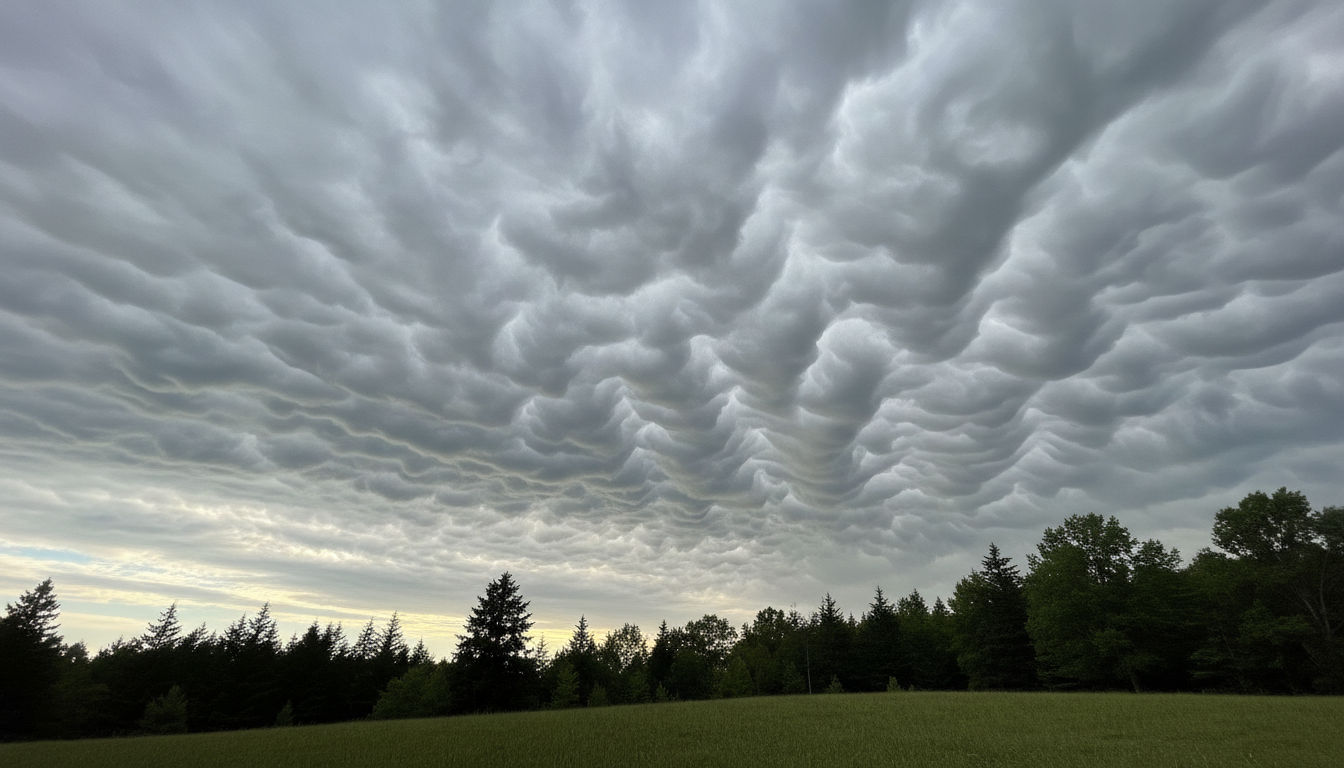
Asperitas is the name for a striking wave-like feature on the underside of a cloud. Instead of a smooth, flat base, the sky looks as if a rough ocean has been turned upside down. The shapes may be rounded, sharply pointed or irregular, with patches of light and shadow. Asperitas is a supplementary feature, not a separate basic cloud type.

What does asperitas actually look like?
Picture the underside of an overcast sky becoming a patchwork of bulges, troughs and waves. Some areas look smooth and rolling; others resemble crumpled fabric. Contrast from uneven sunlight makes the ridges much more visible. The World Meteorological Organization (WMO) describes the appearance as localized waves that are less orderly than the regularly aligned ripples of undulatus clouds.
The feature is observed most often in stratocumulus or altocumulus. A photograph alone does not always reveal the cloud height or the atmospheric conditions that produced it, so avoid assuming every wavy sky is asperitas.
Asperitas vs. undulatus: the difference
Undulatus usually consists of broad, relatively regular cloud bands or parallel ripples. Asperitas is more disorganized: its ridges vary in orientation, depth and shape, like a stirred-up sea. The distinction is about the cloud’s visible structure, not a forecast of storm intensity.

How do these cloud waves form?
The exact pathways are still an area of atmospheric research. Air moving through layers with different wind speeds, temperatures and stability can develop waves. Where that motion deforms an existing cloud sheet, some areas become thicker or thinner, producing a dramatically uneven underside. The visible wave pattern does not mean the entire cloud is solid, or that the cloud base is physically touching the ground.
The appearance can change quickly as lighting shifts or clouds evolve. The most useful way to document an unusual formation is to photograph the whole sky, note the place and local time, and compare what you saw with the official cloud atlas.
Does an asperitas sky mean a tornado or severe thunderstorm?
No. Asperitas is not, by itself, a tornado warning or proof that severe weather is imminent. It can occur in unsettled conditions, but you need a real forecast, radar or local alert to assess storm risk. If thunder is audible, take shelter indoors regardless of the cloud’s label.
Frequently asked questions
Is asperitas a new species of cloud?
No. It entered the WMO International Cloud Atlas in the 2017 revision as a supplementary feature. Calling it a newly discovered cloud species is a common misconception.
Can I see it without a storm?
Yes. The unusual cloud-base texture may be visible even without lightning or heavy rain at your location. Weather conditions determine the actual risk, not appearance alone.
Authoritative reference
See the WMO International Cloud Atlas definition of asperitas and its classification of supplementary cloud features.
Leave a Reply